|
|||||||||||||||||||||||||||||||||||
|
|||||||||||||||||||||||||||||||||||
|
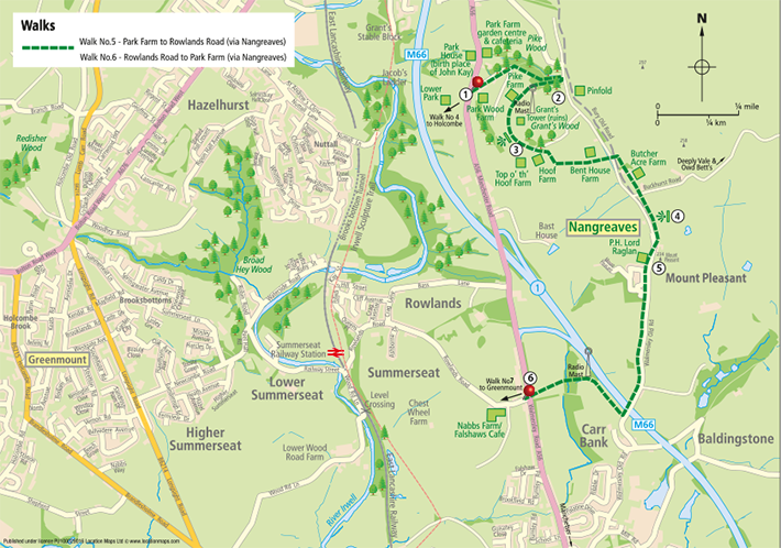
| Click to download walk | |
| Park Chapel opened in 1798 and the last service was in 2001. | |
 Follow the lane up past the Park Wood Farm yard and up the hill into the much bigger yard and storage area. Go through the five- barred gate in the far left hand corner of the yard. (Not through the smaller gate beside it). Follow the lane up past the Park Wood Farm yard and up the hill into the much bigger yard and storage area. Go through the five- barred gate in the far left hand corner of the yard. (Not through the smaller gate beside it).Follow the old disused track uphill through a very pleasant stretch of Park Woods (which can be rather boggy in places after rain). Go into the farmyard and go left up the track to the left of the farmhouse. |
|
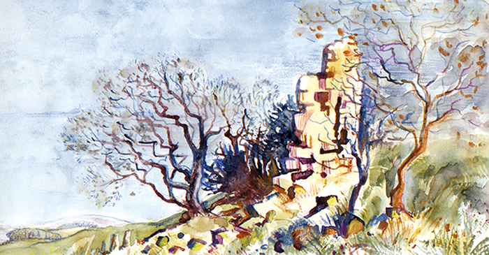
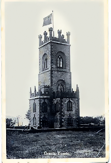
| The grassy bank in front of the tower makes an ideal spot for a picnic with wonderful views from the Pennines on the left across the Cheshire Plain to the distant mountain peaks of North Wales on the right. The tower was much more ornate and built 24 years before Holcombe Tower in 1828 by William and David Grant (said to be the model for the philanthropic Cheeryble brothers in Dickens’ 1838 novel Nicolas Nickleby) as a memorial to their father William. They chose the location on Top o’ th’ Hoof, because many years earlier when the whole family had walked fromScotland, having fallen upon hard times, hoping to find work in Manchester, they stopped here to rest their weary bones. Their father looked into the valley below and said it was the nearest thing, they had seen throughout the trip to their home in the Highlands, and if they could ever afford it, they would return one day. Well, they did return as wealthy men and built the biggest most modern calico bleaching and finishing works in Europe (Square Mill) and within ten years, the firm of William Grant and Brothers became one of the most famous in Lancashire. Ramsbottom was transformed as a result. Edwin Waugh, the famed Lancastrian poet, whilst convalescing in a room in the tower, wrote “Lie thi’ doon laddie”. But perhaps the most famous resident of all was ‘Steeple Jack’ and his family. Steeple Jack’s real name was James Wright who came down from Dundee to Ramsbottom to repair one of Grant’s factory chimney’sand took up residence in the Tower living there for years and becoming known to all and sundry as ‘Steeple Jack’. This nickname later became the title of anyone working on church steeples or mill chimneys. In 1943 when the Tower had fallen into disrepair, Ramsbottom Council did offer to buy it but sadly before the sale went through the tower collapsed on the 21st September 1944 in a violent storm. |
|
 Continue the walk by following the somewhat indistinct remains of the old track that curves from the tower around the hill behind the Top o’th Hoof Farmhouse. Continue the walk by following the somewhat indistinct remains of the old track that curves from the tower around the hill behind the Top o’th Hoof Farmhouse.Go through the pair of old stone gate posts and down the overgrown track, which can be soft and boggy after rain, around the bend as far as large pair of ornamental iron gates in the bottom left hand corner of the field. Cross the wooden stile just before the gates and the small stone stile on the far side, then full steam ahead up to the road at the top. Upon reaching the road, turn right almost immediately down the narrow path beside the Hoof Farm garden fence. Go over the stile in the fence and head straight across the wide meadow to the far side. Head for a stone stile in the wall between two tall pine trees. Go through the garden, across the front of the house and down the drive of Bent House Farm, turning right onto Bury Old Rd. |
|
| This was the old turnpike road between Bury and Burnley, in 1790 it was improved by the famous road builder John Metcalf of Knaresborough who was known as “Blind Jack” due to losing his sight as a child from smallpox. Apparently he was a smuggler before he became a road builder. | |
| Here refreshments are available at the Lord Raglan, a welcoming 19th century family-run pub and micro-brewery. Mount Pleasant is a good example of a ‘factory’ village in the Nangreaves area. The village started life when John Hall bought the land from Richard Nangreaves in 1819 to open a new mill. In 1820 his core business was the manufacture of quilts. The new mill provided the warp and weft for home-based handloom weavers. employing as many as thirteen hundred from as far afield as Bolton and Leigh. However, with the ever increasing mechanisation of the textile industry more of the weaving was done in the mill than outside and the last of handloom weaving was in 1888. Thus the village expanded to accommodate the additional spinners and weavers employed within in the mill. Itself. This fact together with the remoteness of Nangreaves combined to make Mount Pleasant a largely self-contained mill village which became a conservation area in 1973. The mill eventually closed in the 1980’s and was partially demolished. The stone was used to build additional cottages and convert the village into a residential community. |
|
|
|
| BACK TO TOP | |
 Continue down the stone cobbled Bury Old Road to the bridge over the M66. Turn right on the far side of the bridge, over the wooden stile. Follow the wooden motorway boundary fence almost as far as the phone mast. Then go down to the phone mast’s access track.