|
Click to download walk |
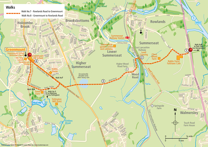
 Walk down Rowland’s Road, past Falshaw’s Ice Cream Parlour and Nabs Farm and turn first left down the track to Chest Wheel Farm. Just before the farmhouse, turn left through the ‘kissing gate’ and follow the path around the front of the house. Emerging into a large meadow, proceed downhill following the hedge on the right. Go through the ‘kissing gate’ at the bottom, turn right over the stream and briefly join the Irwell Sculpture Trail. Walk down Rowland’s Road, past Falshaw’s Ice Cream Parlour and Nabs Farm and turn first left down the track to Chest Wheel Farm. Just before the farmhouse, turn left through the ‘kissing gate’ and follow the path around the front of the house. Emerging into a large meadow, proceed downhill following the hedge on the right. Go through the ‘kissing gate’ at the bottom, turn right over the stream and briefly join the Irwell Sculpture Trail. |
| The Irwell Sculpture Trail is the longest public art scheme in England that runs along a well-established footpath for 30 miles between Salford Quays and Bacup containing 28 art pieces, the work of both national and international artists. Just south is Burrs Country Park and Castlestead, the site of a ‘Promontory Fort’ overlooking the Irwell. Archaeological excavation of the site in 1992 revealed that it dates back to the late Iron-Age, having been occupied between 200BC and AD250. This means that the settlement site continued in use long after the Romans had arrived in Britain. The site is now a ‘Scheduled Ancient Monument’ in recognition of its national importance. |
 Fifty metres along the trail, go left again through the gate and down to the level crossing and cross over the East Lancashire Railway track. Fifty metres along the trail, go left again through the gate and down to the level crossing and cross over the East Lancashire Railway track.
|
This East Lancashire Railway opened in1846 to serve local communities, but closed to passenger traffic in 1972 and commercial traffic in 1980. A spirited campaign restored the Bury to Ramsbottom line and it reopened in 1987. Since then this heritage line, now carrying 120,000 passengers a year, has been extended twice to now run between Heywood and Rawtenstall.
It is run by volunteer members of the East Lancashire Railway Preservation Society every weekend and bank holiday throughout the year (and mid-week in summer). They arrange all sorts of events from a Real Ale Trail to Steam Experience Days, War Weekends and Santa Specials at Christmas. It also an excellent spot to capture steam engines working hard as they round the bend coming up from Bury. It is difficult to imagine now, that years ago every morning around 8.15 the London train made the ground tremble, roaring south, over this very spot. |
 Go down the steps and cross the bridge over the River Irwell and follow the asphalt road through the small hamlet of Wood Road. Turn right before the bridge for Summerseat Station or for the café at the Garden Centre. Go down the steps and cross the bridge over the River Irwell and follow the asphalt road through the small hamlet of Wood Road. Turn right before the bridge for Summerseat Station or for the café at the Garden Centre.
 Leaving the hamlet, follow the unsurfaced track uphill until it levels out and at the sharp left hand bend, go straight ahead over the wooden stile alongside the fence on the right. Leaving the hamlet, follow the unsurfaced track uphill until it levels out and at the sharp left hand bend, go straight ahead over the wooden stile alongside the fence on the right.
|
| Please note: after prolonged or heavy rain this path may be flooded at the far end and it may be advisable to continue along Wood Road until its junction with Brandlesholme Rd and turn right and then first left up to Greenmount instead. |
If you look backwards whilst on this stretch, to the hills in the distance, you will note a distinct notch or vee above Walmersley which is a classic example of a glacial overflow channel.
At the next stile turn right to join Longsight Road. Cross Longsight Road on to the footpath in the field directly opposite, cross the wooden footbridge halfway across the field (note the ‘kissing gate’ at the end of the footbridge is rather a tight fit for the fuller figure) and then bearing slightly left go straight on to join Brandlesholme Rd.
Turn right for Greenmount, when passing Nabb’s House, note the interesting folly built in the corner of the garden. |
| John Turner, an eccentric had this ‘castle’ built as a summer house in 1867. It has always been known as ‘Images’ as it was covered in gargoyles, said to represent the faces of Greenmount villagers to whom he had taken a particular dislike. The heads of the gargoyles are hollow and in wet weather water dribbles from their mouths and ears, but sadly many of them have been stolen. As you pass it try and spot just over the wall, the carved stone threatening figure of a man ready to hit any passer-by with a large stone. |
 Continue past the Cricket Club on the left into the centre of the village and the Toby Carvery (Previously the Bull’s Head) opposite Greenmount Old School. Continue past the Cricket Club on the left into the centre of the village and the Toby Carvery (Previously the Bull’s Head) opposite Greenmount Old School. |
| Greenmount Village owes its existence to the building of a Sunday school in 1848 in what was then the outskirts of the village of Tottington. The founders named it Green Mount Independent Sunday School. People living nearby included Green Mount in their postal address and this gradually extended to the surrounding area and soon it became a village. The original Sunday school is now the community centre owned by the church and now called Greenmount Old School. |
 |
| BACK TO TOP |
| |
| |
| |
|
|